US Army Corps of Engineers NY/NJ Harbor and Tributaries Study
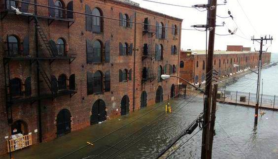
The US Army Corps of Engineers (USACE) is developing a coastal resilience plan to mitigate the risks posed by storms like Superstorm Sandy, specifically for the New York-New Jersey Harbor and Tributaries Study (NYNJHATS). The NYNJHATS plan is a coastal storm risk management plan for the New York-New Jersey region. Spanning 2,150+ square miles, 900+ miles of shoreline, and 25 counties, this is one of the largest projects the US Army Corps of Engineers has ever undertaken and is expected to bring approximately $63 billion of investment to the region if fully funded and implemented. This is a decades-long project that has been underway since 2016 and is nearing the end of the planning phase. From a variety of plans, they selected plan 3B to carry forward into the public comment period (2022-23), design phase (2024-2030), and construction (2030+). However, due to recent changes in federal priorities, the Army Corps has shifted focus to three select Early Actionable Elements, the details of which were released on July 24, 2025. These are small-scale, targeted projects to add resiliency to subsections of the larger NYNJHATS region, located in East Harlem, Oakwood Beach in Staten Island, and East Riser in New Jersey. These plans should increase protection against multiple climate change coastal threats, focusing not only on storm surge but also on sea level rise, extreme rainfall, and other coastal risks. We have worked to encourage USACE to improve the plan and do their duty as mandated by WRDA 2020 and WRDA 2022, and prioritize our most vulnerable communities. We want to see their final plan include:
- Protection for all of our most vulnerable communities (EJ, low-income, people of color, etc)
- Focus on EJ priorities
- Multi-hazard risk mitigation (storm surge, sea level rise, rain inundation, and other flood risks)
- Fully exploring natural and nature-based solutions for the plan and incorporation of as many as possible/practicable
- Multiple social, environmental, ecological, and economic benefits, and partnerships with other government agencies that can enhance a variety of solutions
See our full public comments on the Tentatively Selected Plan 3B here.
Waterfront Justice Project
In 2010, NYC-EJA launched our Waterfront Justice Project, New York City’s first citywide community-based resiliency campaign. When the City of New York initiated its overhaul of the Comprehensive Waterfront Plan (Vision 2020) in 2010, NYC-EJA began our advocacy campaign to convince the Bloomberg Administration to reform waterfront designations called Significant Maritime Industrial Areas, or SMIA’s. SMIA’s are zones designed to encourage the clustering/concentration of heavy industrial and polluting infrastructure uses. There are only seven SMIA’s in the City – six of which are all classic “environmental justice” communities (i.e. – the South Bronx, Sunset Park, Red Hook, Newtown Creek, Brooklyn Navy Yard & North Shore of Staten Island) – predominantly low income-communities of color.
NYC-EJA discovered that the SMIA’s are all in storm surge zones, and that the City of New York had not analyzed the cumulative contamination exposure risks associated with clusters of heavy industrial use in such vulnerable locations. In collaboration with Pratt Institute, NYC-EJA prepared GIS maps showing the SMIA’s with storm surge zone overlays. Following months of public testimony and media education by NYC-EJA and its members and allies, City officials agreed in 2011 to work with stakeholders to reform SMIA’s and address related community resiliency/climate adaptation issues. (To learn more, please read the Accomplishments column.)
NYC-EJA worked with our members in SMIA communities on a reform campaign to overhaul NYC’s coastal zone management plan, known as the Waterfront Revitalization Program (WRP). At the invitation of the City Council, NYC-EJA advised Council staffers on proposed amendments to the Community Right-to-Know law (which requires facilities that handle hazardous substances to annually report what chemicals are used/stored, and how their emergency planning protects the public in the case of fire, spills or accidental chemical release). NYC Local Law 143 (2013) amended the Right-to-Know law to now include coastal storm surge and hurricane evacuation zones as part of the geography established to: a) require that facilities report the presence of hazardous substances; and b) develop a “risk management plan” to prevent the release of hazardous substances during potential flooding and other extreme weather events.
Our research is helping to identify innovative strategies to build climate-resilient industrial waterfronts while promoting local industrial jobs through two groundbreaking Waterfront Justice Project research partnerships.
The Resilient Coastal Communities Project is a partnership between NYC-EJA and Columbia University’s Center for Sustainable Urban Development. Its key goal is to address the challenges of coastal resilience through a combination of iterative engaged scientific research, community engagement and innovation, and a variety of other supportive and capacity building means. RCCP has been heavily involved in our USACE HATS work and in ongoing research projects. Here you can see our working paper Designing Community-led Plans to Strengthen Social Cohesion: What Neighborhoods Facing Climate-driven Flood Risks Want From Resilience Planning and our scientific article Advancing equitable partnerships: frontline community visions for coastal resiliency knowledge co-production, social cohesion, and environmental justice from our first research project.
For more information on similar initiatives, see NYC-EJA’s Community Resiliency and People’s Climate March pages.
The Waterfront Justice Project Interactive Map is a collaborative effort between NYC-EJA and the Scientist Action and Advocacy Network (ScAAN), aiming to visualize maps created by NYC-EJA through our Waterfront Justice Project (WJP)
As a member of the Grassroots Research to Action in Sunset Park partnership (GRASP), we worked with UPROSE, the Rand Corporation, and The LifeLine Group on a community-based participatory research project in Sunset Park to support community-based actions seeking to reduce contamination risks associated with storm surge-vulnerable industrial waterfronts while building climate resiliency. This multi-year research project – funded by the National Institute of Environmental Health Sciences (NIEHS) -sought to understand the public health risks posed by fugitive chemicals from the automotive industry and increase community capacity to address those risks.
NYC Industrial Waterfront Communities Pollution Prevention, Toxics Reduction, and Resiliency Planning
NYC-EJA worked in partnership with the NYS Department of Environmental Conservation (NYS-DEC) and the Rochester Institute of Technology (RIT) NYS Pollution Prevention Institute on the EPA-funded “NYC Industrial Waterfront Communities Pollution Prevention, Toxics Reduction, and Resiliency Planning” project in the South Bronx Significant Maritime and Industrial Area (SMIA). This 2-year project involved helping auto-related businesses to identify and implement cost-effective strategies aimed at pollution prevention, toxics reduction, and climate adaptation.
For more information on similar initiatives, see NYC-EJA’s Community Resiliency and People’s Climate March.

