Waterfront Justice Project Interactive Map
As the threats of climate change increase, destructive storms like Superstorm Sandy, Hurricane Katrina, and Hurricane Harvey will expose the vulnerabilities of costal communities overburdened by industrial and chemical facilities. Click the preview of the map below to launch the Waterfront Justice Project Interactive Map where you can explore these communities!
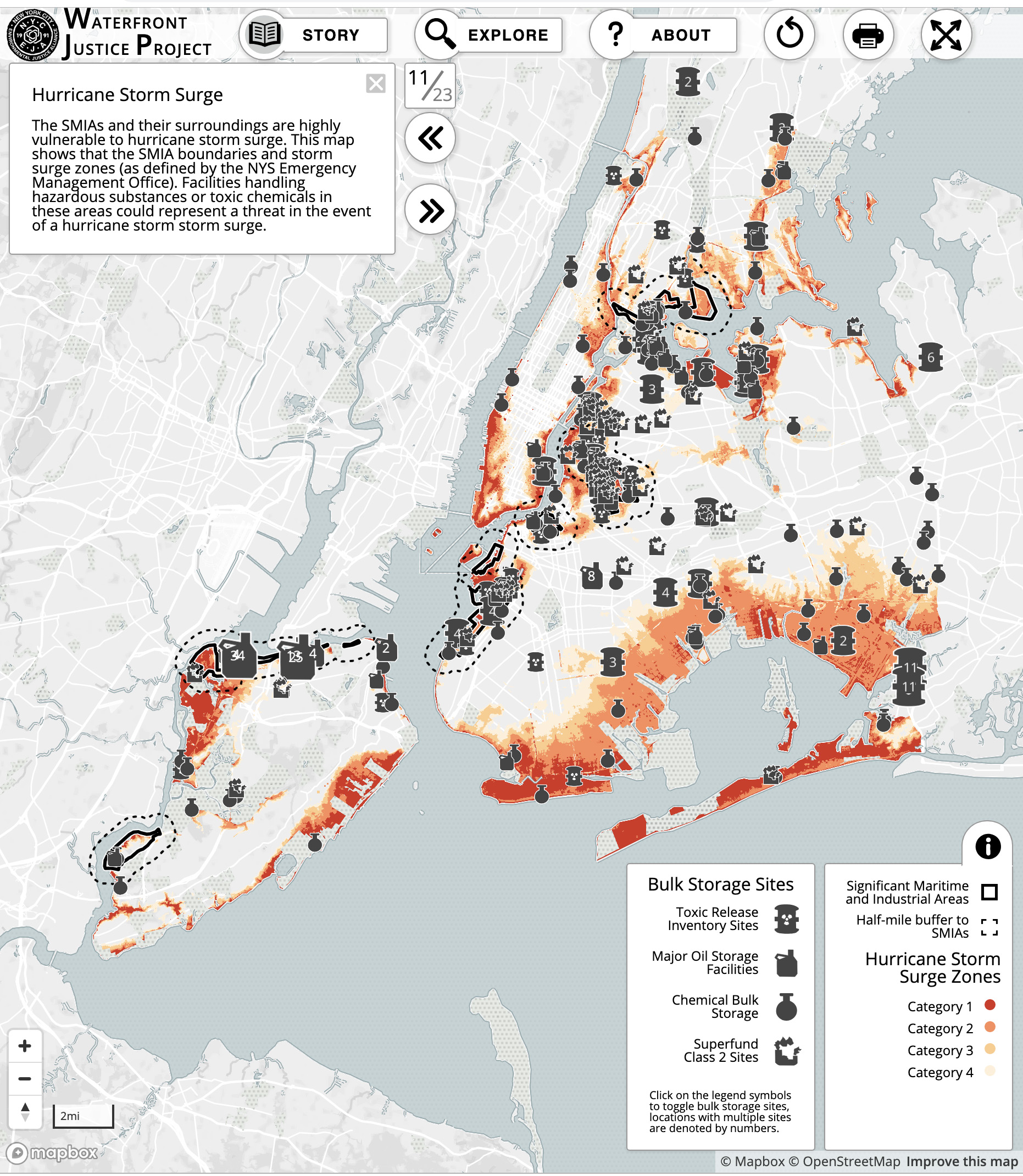
Of interest are NYC’s Significant Maritime and Industrial Areas (SMIAs), clusters of industry and polluting infrastructure along the waterfront. SMIAs are located in classic environmental justice communities- predominantly low-income communities of color – in the South Bronx, Brooklyn, Queens and Staten Island, which are also hurricane storm surge zones. The Waterfront Justice Project is a research and advocacy campaign focusing on community resiliency that seeks to reduce potential toxic exposures and public health risks associated with climate change and storm surge in the City’s industrial waterfront. The Waterfront Justice Project Interactive Map is a collaborative effort between NYC-EJA and the Scientist Action and Advocacy Network (ScAAN), aiming to visualize maps created by NYC-EJA through our Waterfront Justice Project (WJP).
Accomplishments
At the invitation of the City Council, NYC-EJA advised Council staffers on proposed amendments to the Community Right-to-Know law (which requires facilities that handle hazardous substances to annually report what chemicals are used/stored, and how their emergency planning protects first responders and the public in the case of fire, spills or accidental chemical release). NYC Local Law 143 (2013) amends the Right-to-Know law to now include coastal storm surge and hurricane evacuation zones as part of the geography established to: a) require that facilities report the presence of hazardous substances; and b) develop a “risk management plan” to prevent the release of hazardous substances during potential flooding and other extreme weather events.
NYC-EJA worked with our members in SMIA communities on a reform campaign to overhaul NYC’s coastal zone management plan known as the Waterfront Revitalization Program (WRP). Approved by the City Planning Commission and City Council in October 2013, the WRP will for the first time:
- Consider climate change impacts – climate adaptation measures are included in Policy 6 (flooding and erosion) and are woven throughout the WRP, including in Policy 2 (maritime and industrial development)
- Mandate vulnerability assessments by new industrial businesses seeking to site in SMIA’s;
- Ensure that vulnerability assessments reveal potential impacts on residents and workers;
- Consider risks associated with open storage of hazardous materials during extreme weather; and
- Include design guidelines for coastal development.
- Read the report, Environmental Best Management Practices: Pollution Prevention, Climate Adaptation and Toxic Mitigation.
- Read the full report by the New York City Panel on Climate Change, Climate Change Adaptation in New York City: Building a Risk Management Response. The reference to NYC-EJA is in Chapter 5, Public Health Impacts and Resiliency.
- Read the peer review of NYC-EJA’s Waterfront Justice Project in Local Environment: The International Journal of Justice and Sustainability
- Watch as Eddie Bautista of NYC-EJA presents the Waterfront Justice Project at the Garrison Institute.
- See the full Waterfront Justice Project presentation
- For more maps on NYC-EJA’s Waterfront Justice Project, click here.
- Read the peer-reviewed Waterfront Justice Project article in the journal of Environmental Justice (pdf): Fugitive Chemicals and Environmental Justice: A Model for Environmental Monitoring Following Climate-Related Disasters
- NYC Department of City Planning: Waterfront Revitalization Program
- NYC Department of City Planning: Vision 2020: NYC Comprehensive Waterfront Plan / NYC Waterfront Action Agenda (WAVES)